by Don Kostelec
November 18, 2019
In June 2018, a traffic crash on I-84 in Boise resulted in the death of four people and a fire that damaged the Cloverdale Road overpass to the point it had to rebuilt. The old structure was a two-lane overpass with no sidewalks.
The Idaho Transportation Department and Ada County Highway District (ACHD) quickly put a design contract into action and rebuilt the bridge in a year’s time. The new bridge and the adjoining sections of Cloverdale Road now include 5 motor vehicle lanes, a raised bike lane on a portion of the road, and completed sidewalks on both sides.
Prior to the bridge rebuild, the one-mile section of Cloverdale between Overland and Franklin was mostly a three-lane section with sidewalks leading up to the old overpass. There was a traffic signal at the intersection with Emerson to help facilitate the movement of pedestrians to Spalding Elementary School and Sycamore Park.
The completion of a sidewalk network and construction of raised bike lanes (not fully protected, however; they are on what ACHD calls “mountable” curb or rolled curb) is normally a reason to celebrate in the world of active transportation advocacy.
But this project is having the opposite effect. It shows how it takes much more than the construction of a sidewalk and a bike lane to make a Complete Streets all users feel safe traveling upon and across.
Children who walked to Spalding Elementary School before the road widening are now being bused…wait for it…from across the street. This is due to safety concerns expressed by parents when the wider, faster road was opened. The project is now costing the school district extra money to do this busing. Two crossing guards have quit their jobs due to concerns over their personal safety and the safety of children they were there to help ensure they made it across safely.
Three decisions were made in the engineering of the Cloverdale overpass that have suppressed walking and bicycling activity beyond the widening of the road:
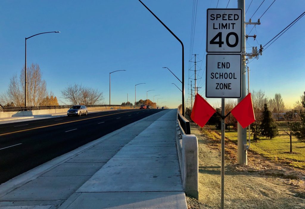
- The speed limit was raised from 35 mph to 40 mph.
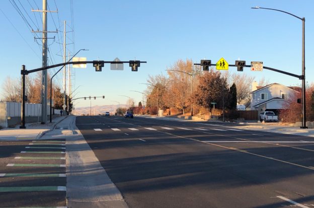
- The full traffic signal at the school crossing at Emerson was changed to a Pedestrian Hybrid Beacon (HAWK) signal.
- The profile of the bridge was raised to provide a higher clearance to accommodate a future widening of I-84.
The Emerson signal is located only 900 feet north of the overpass. Motorists now crest the bridge at a higher elevation and are led down a steeper grade at a higher speed to the school crossing, which is now a confusing Pedestrian Hybrid Beacon.
You can see how those factors have taken away a sense of safety at this intersection and why parents no longer want their kids walking or bicycling to school.

Activity Suppression
The effect the Cloverdale Road project had in suppressing pedestrian and bicyclist activity is a phenomena we are only now starting to understand. Earlier this year I wrote a piece about Vision Zero challenges in small cities for Transportation Alternatives Vision Zero Cities Journal. Streetsblog also published the piece.
Dr. Wes Marshall, of University of Colorado Denver, was kind enough to send me research papers and provide quotes for that story. He noted the suppression effect that road design has on walking and bicycling, especially in suburban areas. The results are a lack of crash data due to a lack of activity.
“Unsafe streets and networks make an area’s crash record look great simply because there’s nobody walking or biking there,” Marshall told me for that article. “Therefore, if we just look at where crashes occur, we never identify places where people don’t feel safe.”
That’s what is playing out now along Cloverdale Road in Boise. You won’t see crashes due to this unsafe design because fewer people are using the road to walk and bike due to the engineering decisions. If it stays the same we’ll probably see a presentation in a few years on how the project reduced vulnerable road users crashes.
Marshall, along with Dr. Nicholas Ferenchak at University of New Mexico, published a 2019 paper titled “Suppressed child pedestrian and bicycle trips as an indicator of safety: Adopting a proactive safety approach” in Transportation Research Part A: Policy and Practice .
In it they state “Traditional pedestrian and bicyclist safety analyses typically examine crashes, injuries, or fatalities. However, this reactive approach only accounts for the places where people are currently walking or biking.”
Central areas of cities and traditional neighborhoods are where most of this activity occurs and, thus, is where most crashes will occur. Almost all of the USA’s safety-oriented funding programs are geared toward this type of Visine Plan approach–make a heat maps of the crashes and fund projects to get the red out.
The result is we don’t fund projects to improve walking and bicycling on unsafe streets where few or no crashes occur due to lack of activity prompted by unsafe design.
Ferenchak and Marshall hypothesize over what a proactive approach to analyzing safety would entail by “examining areas where pedestrian and bicyclist activity is being suppressed because of safety concerns.” They used parent surveys and GIS analysis to conduct the proactive approach analysis to try to determine what factors led to reduced walking and bicycling for children.
The conclusions of the research state: “Findings suggest that proactive safety analyses can effectively complement traditional reactive approaches. Cities that wish to obtain a holistic perspective of their streets’ safety would be prudent to consider both manifested and latent pedestrian and bicyclist safety issues.”

Real Vision Zero
What Ferenchak and Marshall’s finding propose is what I consider part of a real Vision Zero approach to traffic safety.
- Identify where fatal and severe crashes occur.
- Attempt to understand the systems that led to those crashes–road design, vehicle design/condition, human psychology.
- Fix the location where the crashes occurred while also addressing other systemic findings such as vehicle design and enforcement.
- Modify design standards so future roads are no longer engineered with the features that are contributory to those crashes.
- Proactively fix other locations with similar design characteristics in order to prevent future fatal and severe crashes. Prioritize locations with land uses known to be pedestrian and bicyclist activity generators.
The US approach instead throws individual countermeasures at high crash locations , while agencies continue building new roads with they same features as the existing road. It’s practically impossible to get Highway Safety Improvement Program (HSIP) funds unless there has been a fatality.
Some studies have found that continuing to throw individual countermeasures at high crash locations rather than implement systemic changes only leads to a short-term reduction in crashes. Yet, that’s what we fund.
If we took the 5-step approach proposed above, and combined it with recognition that fast, wide roads with minimum treatments for vulnerable road users suppress activity, then we might truly change how roads are designed so people feel safe using them in large numbers.
In the case of Cloverdale, the road cross section is the same five-lane cross section with bike lanes and sidewalks that ACHD has built for the past 25 years. The only subtle difference is the bike lane is slightly raised on a mountable curb rather than being flush with the vehicle travel lanes. I still wouldn’t let my daughter ride a bike on that next 40 mph traffic.
To the engineers, it is a Complete Street, nevermind the fact the result is fewer people willing to walk and bike it. This ultimately leads to elected officials viewing sidewalks and bike lanes as a waste of money since they see few people using them. They aren’t trained well enough to recognize that building only a sidewalk and bike lane on the same fast, wide road does not make it “complete.” Good luck getting funding for the necessary fixes.

